California Gold Rush
California imposes a Foreign Miners Tax, forcing Chinese to pay tax not required of U.S. citizens.
City of Salinas is founded
Central Pacific Railroad recruits Chinese workers to build the transcontinental railroad.
Chinese laborers arrive in Salinas with the railroad.
Burlingame-Seward Treaty between U.S. and China allowing bilateral emigration, freedom from religious persecution in the U.S., but specifically withholds the privilege of naturalization.
First transcontinental railroad is completed.
In the 1870s Salinas Chinatown begins as a service community for seasonal Chinese farm laborers.
Southern Pacific Railroad connects Salinas to Castroville.
Salinas becomes the seat of Monterey County. First Chinatown is established in the vicinity of the N. Main St. Underpass -- bordered by the Southern Pacific RR tracks, San Juan Road (now N. Main St.), Pajaro Street (now Bridge Street) and Lake Street.
Chinese laborers drain lakes and swamps creating 500 acres of arable farmland in and around Salinas.
Page Act bars entry to Chinese, Japanese, and "Mongolian" prostitutes, felons, and contract laborers. "The Order of the Caucasians" forms in Salinas as a secret society advocating employment preferences to white men and women over Chinese or Mongolian labor.
Burlingame Treaty of 1868 is amended to suspend, but not prohibit Chinese immigration, and confirming U.S. obligations to protect the rights of Chinese immigrants already in the U.S.
Congress passes the Chinese Exclusion Act, prohibiting entry of unskilled and skilled laborers and those in mining. Extensions deny U.S. citizenship to Chinese immigrants, entry of new laborers, and reentry of laborers who departed the U.S. before passage of the Act.
Scott Act renders 20,000 reentry certificates null and void.
The 1890 Census shows 1,667 Chinese residents in Monterey County, out of a total of 18,637.
Geary Act extends the Chinese Exclusion Act of 1882. Renews exclusion of Chinese laborers for 10 years, requires all Chinese to carry certificates of residence and identity at all times, and prohibits Chinese to be court witnesses or receive bail for writ of habeas corpus.
Fire completely destroys Salinas' first Chinatown. Six Chinese merchants negotiate with landowner Eugene Sherwood to lease 8 lots on the corners of Soledad and E. Lake Streets. They begin construction of Salinas' current Chinatown.
First Japanese farmers and merchants arrive in Salinas.
U.S. vs. Wong Kim Ark: The Supreme Court rules that a child born in the United States of parents of Chinese descent who reside in the United States becomes a U.S. citizen at birth, by virtue of the first clause of the 14th Amendment.
At the edge of Salinas, Klaus Spreckels opens the largest sugar beet factory in the world, requiring 30,000 workers.
The Philippine Declaration of Independence from Spain. U.S. wins the Spanish American War. Spain cedes the Philippines to the U.S.; Hawaii is annexed; Puerto Rico and Guam become U.S. possessions; Cuba becomes independent.
One thousand Japanese immigrants are in the Central Coast region. 80% are in farming and agriculture.
The Chinese Association of Salinas purchases land for a Chinese Cemetery on Natividad Road for a $100 gold coin.
Nihonmachi /Japantown is established on Lake Street.
Fire destroys the Joss House (Chinese temple) at 1 Soledad St.
The Japanese and Korean Exclusion League is formed on 14 May 1905 in San Francisco and includes 67 labor unions.
San Francisco earthquake and fire destroy City Hall and Hall of Records, including immigration records. Chinese immigrants claim U.S. citizenship and right to bring wives and children, known as "paper daughters and sons." Officials cannot prove otherwise.
The U.S./Japan "Gentlemen's Agreement" eases immigration restrictions on wives, parents, and children of Japanese living in the U.S. Japan agrees to halt emigration of laborers to U.S. Filipinos allowed to emigrate to Hawaii. Korean laborers banned from immigrating to U.S.
Seven prominent Chinese men in Salinas Chinatown cut their queues, as Chinese government no longer requires this badge of loyalty.
Suey Ying Tong members try to assassinate Hop Sing Tong member Shorty Lee. Lee survives barrage of gunfire at Hop Hing Lung Co. store at 20 Soledad St. (today 12 1/2). Four are killed and four captured and convicted in Superior Court in Salinas.
California Alien Land Law prohibits aliens ineligible for citizenship from owning agricultural land or holding long-term leases over three years. Chinese and Japanese immigrant farmers are affected. Many buy land in the name of their male children born in the U.S.
World War I begins.
Fort Ord is established at the former Camp Gigling.
The U.S. enters WWI.
National Prohibition Act, prohibiting manufacture, transportation, and sale of alcoholic beverage over .5%.
The California amendment to the Alien Land Law of 1913, prohibits aliens ineligible for citizenship to lease land on a short-term basis and acquire agricultural land via stock companies.
The Japanese government stops issuing passports to picture brides.
Filipino contract laborers begin arriving in Salinas to work in the agricultural fields.
Two-story Suey Sing Association (Tong) meeting hall is completed at 102 E. Lake St., in the Japantown section of the Chinatown area.
California further limits the right of U.S.-born children to hold land in trust for an alien parent, in an effort to stem the practice used by many Issei to acquire land for farming.
The Immigration Act of 1924 provides that no alien ineligible to become a citizen can be admitted to the U.S. as an immigrant. This was aimed primarily at Japanese and Chinese aliens.
The Buddhist Temple of Salinas is formally organized.
Salinas Buddhist Temple is built at 14 California Street.
Dedication ceremonies of new Bing Kong Tong Chinese Free Masons Meeting Hall, 18 Soledad St. (today 12). Ceremonies last two days and nights.
The Wall Street crash ushers in the Great Depression.
Luis Agudo founds the Philippines Mail. It is first published out of the mezzanine balcony of the Manila Hotel, owned by Bernard Lozares Sr. Later, it is published out of Delfin Cruz's apartment above Lozares' Luneta Barbershop on Sausal St.(now Market St.).
End of Prohibition.
The first Salinas Lettuce Strike: The Filipino Labor Union and the A.F.of L. Shed Workers union strike for higher wages and better conditions. The strike fails and vigilante groups burn a Filipino labor camp, driving workers out of Salinas at gunpoint.
The Tydings–McDuffie Act (officially the Philippine Independence Act) provided for self-government of the Philippines and for Filipino independence from the U.S. after a period of ten years. It also established strict limitations on Filipino immigration.
A Bonsho bell, the largest of its kind in the U.S., is hung in an open bell tower at the Buddhist Temple on California Street.
Delfin Cruz becomes the editor of the Philippines Mail, and continues in this role until the mid-1980s.
Filipino Community Church is built at 21 California Street.
Headquarters of the Chinese Association of Salinas is completed at 1 California Street, one block from Soledad Street, becoming the Chinese community center with a Chinese School, playground, meeting hall, offices, and kitchen.
Police raid two gambling "resorts" at 47 Soledad St. and 4 Soledad St. in Chinatown, arresting 250 patrons and 14 Chinese for violating the city anti-gambling ordinance. Both establishments are destroyed by officers "wielding sledge hammers and axes."
Los Angeles-born film star Anna May Wong appears at the Salinas Armory to raise funds for China war refugees during a gala ball sponsored by the Chinese Association of Salinas.
The Alien Registration Act requires fingerprinting of all aliens and makes it unlawful to advocate or teach the overthrow of the U.S. government or belong to any group advocating such action.
Fort Ord becomes a Basic Training center.
Urabe Park, on land donated by John Urabe on E. Lake Street (today behind the Cristo Rey Catholic Church and the Filipino Community Hall), is renamed Schneider Park because of anti-Japanese sentiment in Salinas.
The P.I. (Philippine Islands) Market opens at 34 Soledad Street, offering a modern, self-service design with separate grocery, meat, produce, beer and wine departments.
The Japanese attack Pearl Harbor, in Hawaii. The United States enters WWII.
In February, Roosevelt signs Executive Order 9066 ordering all persons of Japanese ancestry "excluded" from residing along the West Coast. In April, all Salinas Japanese are taken into temporary detention at the Rodeo Grounds; in July they are incarcerated in Poston, Arizona.
The Japanese army forcibly marches 60-80,000 Filipino and U.S. prisoners of war in the Bataan Death March. Salinas Company C of the 194th Tank Battalion loses a significant number of men, fueling strong local anti-Japanese racism after the war.
The Bracero Program enables the importation of contracted Mexican labor to the U.S. Thousands of Mexican farm laborers are brought to the Salinas Valley, just weeks after the Japanese are deported to internment camps. The program officially ends in 1964.
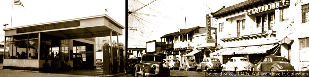
The new Republic Café opens at 37 Soledad Street and becomes known as the best and favorite dining experience in Chinatown, frequented by members of the Chinese, Japanese, Filipino communities especially. The Café closes definitively in 1988.
Mexican Bracero program is established, bringing contract labor to work the agricultural fields.
-
The Chinese Exclusion Act is repealed by the Magnuson Act, allowing naturalization of Chinese. However, it continues the ban on ownership of property and businesses by ethnic Chinese. The Magnuson Act is not fully repealed until 1965.
Some Issei, Nisei, and Sansei return to Salinas after internment in Poston, Arizona. Many relocate elsewhere.
The War Brides Act allows non-Asian spouses, natural children, and adopted children of U.S. military personnel to enter after World War II.
U.S. drops the Atomic Bomb on Hiroshima (August 6) and Nagasaki (August 9); Japan surrenders (August 14), ending World War II.
Desegregation of the Armed Forces.
The U.S. recognizes the independence of the Republic of the Philippines as of July 4, 1946, and relinquishes U.S. sovereignty over the islands. The Philippines declared independence from Spain in 1898 but that declaration was never realized.
Salinas Suey Sing Association (tong) hosts national Suey Sing convention at its meeting hall, 102 E. Lake St.
The War Brides Act is amended to temporarily allow Asian spouses of military personnel–but not their children–to immigrate if the marriage occurred no later than 30 days after the law's enactment.
Amendment to the 1945 War Brides Act allows Chinese American veterans to bring brides into the U.S.
Selective Service Act provides for registration of all men 18 - 25 and induction of men 19 - 25, to maintain the Army, Air Force, and Marine Corps.
The People's Republic of China is established after winning control of the mainland from Chiang Kai-shek. He and his Nationalist party supporters flee to the island of Taiwan.
The McCarran-Walter Act allows immigration based on ethnic quotas. Chinese women allowed to immigrate under same conditions as men; Japanese granted a token immigration quota and can become naturalized U.S. citizens.
The California Supreme Court invalidates the Alien Land Laws as a violation of the equal protection clause of the 14th Amendment to the U.S. Constitution.
The Salinas lodge of the national Chinese American Citizens Alliance is established.
The Filipino Community of the Salinas Valley is incorporated.
The Filipino Community of the Salinas Valley dedicates its community hall at 250 E. Lake Street, today 250 Calle Cebu.
Salinas Chinese Youth Association is formed by Chinese American Citizens Alliance, Salinas Lodge #11.
Victory Mission opens on Soledad Street.
Fire destroys the Suey Sing Association (tong) meeting hall, built in 1922 at 102 E. Lake St., in the Japantown/Nihonmachi section of Chinatown.
Homes and businesses in Chinatown are demolished as part of urban renewal.
Over 400 delegates attend a weekend dedication ceremony for the newly constructed Suey Sing Association (tong) meeting hall at 23-25 Soledad Street.
Over 300 delegates attend weekend dedication ceremonies for the newly constructed Bing Kong Tong Chinese Free Masons meeting hall at 16 Soledad Street.
The Immigration and Nationality Act abolishes national origins formula for immigration, opening the way for Asian and African immigration. The new system is based on country of origin quotas, preferred skills, and family relationships.
The Agricultural Workers Organizing Committee (AWOC) led by Filipino organizer Larry Itliong, calls a grape strike in Delano on September 8. The National Farm Workers Association, led by Cesar Chavez, walks out in support of the AWOC.
The AWOC and the NFWA join forces to form the United Farm Workers Organizing Committee. In 1972, the UFWOC becomes the United Farmworkers Union.
Through Japanese American efforts, the original name of "Urabe Park" is restored to the park, in honor of John Urabe who donated the land. The name had been changed to Schneider Park in the early 1940s, reflecting racist sentiment toward the Japanese.
During the 1970s, the last families leave Chinatown, as a result of urban renewal.
The People's Republic of China gains entry into the United Nations; Taiwan is expelled.
Fort Ord ceases to be a training center and becomes the post of the 7th Infantry.
Urban renewal re-routes Market Street. Chinatown becomes a closed enclave.
The stretch of E. Lake Street, between Front (now Sherwood) and Sun Streets is renamed Calle Cebu, in honor of Salinas' sister city Cebu, in the Philippines. A dedication ceremony is held.
Construction of the new Salinas Buddhist Temple at 14 California Street is completed and the first Issei Pioneer Museum in the U.S. is dedicated on the site.
Hollywood comes to Soledad Street to film scenes for CBS production of Steinbeck's East of Eden, with Jane Seymour and Lloyd Bridges. Locals are cast as extras and façades of the Republic Cafe and Green Gold Inn are transformed into bars, gambling halls and brothels.
1980s - The homeless establish themselves on Soledad Street.
Bars and brothels in Chinatown are closed.
The CBS TV production of East of Eden is broadcast in primetime, including a couple of scenes filmed on Soledad Street, representing old Chinatown.
The congressional Commission on Wartime Relocation and Internment of Civilians holds country-wide hearings, concluding that the internment was a "grave injustice" and Executive Order 9066 resulted from "race prejudice, war hysteria and a failure of political leadership."
Catholic Workers distribute 65 egg salad sandwiches from the back of their car
Dedication ceremonies at Sherwood Park for memorial garden and plaque to the 3,586 Japanese Americans detained from April to July 1942 at the Rodeo Grounds. Detention site is now a State Historical Landmark.
The Swinging Door relocates from Market Street to 47 Soledad St.
Dorothy's Place Community Kitchen is opened at 45 Soledad Street. Guests sit in a dining room.
The Republic Café at 37 Soledad Street closes for good after 46 years in business.
President George Herbert Walker Bush signs into law an entitlement program to pay each surviving Japanese American internee $20,000.
Base realignment and closure commission of Fort Ord. The next year, California State University Monterey Bay is created, occupying one fifth of the Fort Ord land.
Buddhist Temple of Salinas and Franciscan Workers form a non-profit organization to oversee services for the homeless. The city of Salinas buys the Green Gold Inn for homeless services.
Homeless services move to Chinatown.
California State University Monterey Bay opens its doors.
Dorothy's Place Hospitality Center opens at 20 Soledad Street.
Homeless Summit, Soup Line Forum, Beautification Day events
Chinatown Neighborhood Summit to discuss the future of Chinatown.
CSUMB receives HUD grant to fund redevelopment planning process.
CSUMB Community Learning Center and the Community Garden open on Soledad Street.
Chinatown Renewal Plan.
CSUMB students and faculty begin collecting oral histories of Chinatown from members of the historic communities.
The first Asian Festival is held in the Salinas Chinatown area, celebrating the history and culture of the Asian communities that have lived, worked, worshiped, and gathered in the area since 1872.
Chinatown Rebound Plan.
The Republic Café is placed on the National Register of Historic Places. A groundbreaking ceremony launches building renovation for future site of the Salinas Chinatown Cultural Center and Museum.
With a Housing and Urban Development (HUD) grant, the Republic Café building is re-roofed and stabilized.
Independent Filipino, Mexican and Japanese unions in Southern California organize together as the Agricultural Workers Unions of America.
The Asian Cultural Experience is incorporated as a community non-profit organization dedicated to the historic and cultural preservation of Salinas Chinatown.